Hiking
Trails galore interlace the countryside around Creede and throughout Mineral County. Public lands, which constitute 96% of the county, provide ample access to Forest Service trails, many of which carry multi-use designations (Descriptive brochures and maps of Forest Service trails and roads are available at the Creede Ranger Station on South Main Street).
The Continental Divide Trail and the Colorado Trail are two favorite high country hiking routes that pass through Mineral County. Regional Volksmarch trails are clearly marked.
Mineral County has constructed a trail leading south from the Creede ballpark. This new trail affords a pleasant recreational environment for bikers, hikers, and joggers.
Our Favorite Short Hikes (Half to 3-Hour Hikes)
‘Up and Over’
Up & Back or Up & Around (3mi); significant climb to top
The most well-known hike in the area can be hiked in either direction. The trailhead is across La Garita Street from gas station. Three quarters of a mile later and 800 feet up, you’ll reach the pinnacles that tower above Main Street. Find a rock and take a break while you look down on town and the valleys of the Creede Caldera. If you're hiking with younger kids, head back the way you came. Otherwise descend over the back, through pine trees and along the mountainside - there are a few steeper drop-offs that require attentive hiking. Keep right at two forks to come down into East Willow/North Creede. From there, stroll less than a mile downhill back to town.
Distance from Creede: Starts in Town.
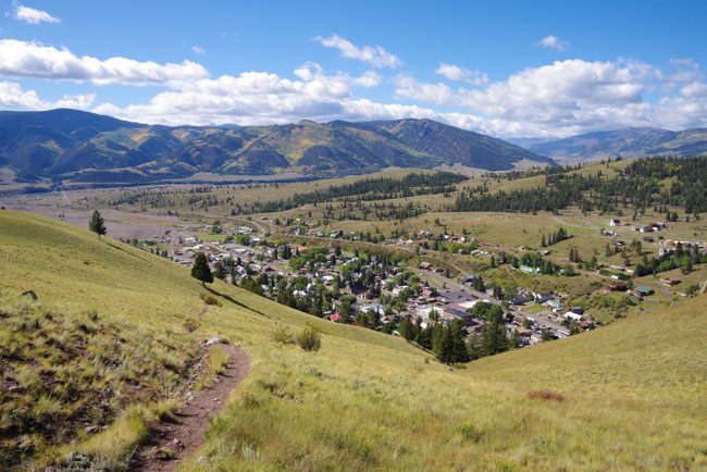
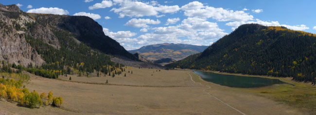
Up & Over View of Creede
South Clear Creek Falls @ Silver Thread Campground
#899 Down and Back; Restroom at trailhead
From the south end of the campground, an 1,100 foot hike (about .2 miles) is along a well-maintained trail and ends at a dramatic and beautiful waterfall! This is a perfect hike for young kids.
Directions from Creede (about 23 miles): Travel towards Lake City from Creede on Hwy 149 for approx 23 miles to the campground sign. Turn right at sign into campground. The turn-off is located approximately ½ way between Creede and Lake City, and just a ½ mile from the famous North Clear Creek Falls.
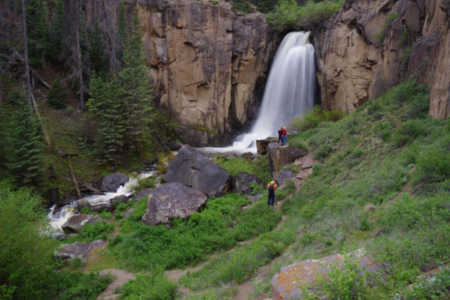
Photo by Bob Seago - South Clear Creek Falls
Hobbit Trail
Up and Back; moderate elevation gain
This hike is the favorite of many locals. This hike starts about a mile and a half north of town along the Bachelor Loop. The trail takes you to the top of Campbell Mountain and overlooks East Willow and a few old mining structures (including the Kentucky Belle mine!). Experienced hikers might opt to clamber down the last two hundred yards for a spectacular view of Creede.
Directions from Creede (2.6 miles): Drive north through town and up the Bachelor Loop Road (FDR #503) up the Black Pitch about 2.6 miles. There is ample parking and the trail head is located at stop #6 on the Bachelor Loop Tour. The trail starts on the east going into the trees.
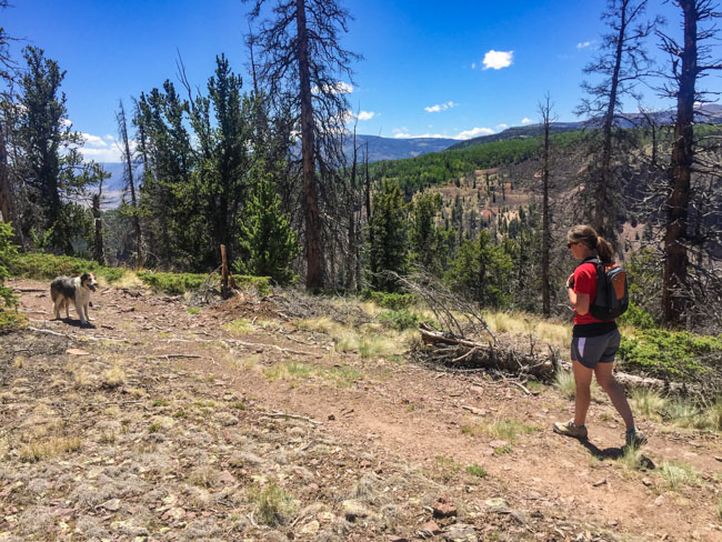
Photo by B4Studio - Hiking the Hobbit Trail
Deep Creek Trail
#806 Up and Back; gradual climb up
This is a great day hike trail just outside of town. The trail follows Deep Creek up its canyon and alongside beaver ponds. Beautiful mountain views and wildflowers! At the trailhead, first note the grave of a young pioneer; the trail switchbacks for first 1/8 mile through trees, then becomes a slight incline through the meadow. The meadow then gives way to in-and-out shade as you hike up and along the creek. You will come to a foot bridge about an hour in to the hike. This is a great place to rest (and turn around if you have kids). Hike out is all downhill!
Directions from Creede (3 miles): Travel towards Lake City from Creede on Hwy 149 for approx ½ mile. Turn left off the highway onto Airport Road. Continue past the airport and across the river. You will intersect FDR #550 (Deep Creek Road). Turn right on Deep Creek Road and go up and around the corner; turn left onto the road and follow it up to the tree line.
Miner's Creek Trail
#803 - Up and Back; slight climb for first mile
Scenery, shade and solitude are available along this trail! Park near the cabin at the trail head at the end of Miner's Creek Road. The trail immediately crosses the creek and parallels it in the narrow canyon bottom. You'll likely get your shoes wet, and note that foot crossings can be dangerous during early summer runoff. After crossing the creek several times, the trail begins to climb out of the creek bottom and through some dense stands of aspen along the southwest facing slopes of Miners Creek. After climbing for about a mile, the trail will turn and cross Miners Creek Drainage. The trail will wander from the creek and traverse through some small open parks and scattered spruce/fir stands.
Directions from Creede (about 6 miles): Travel towards Lake City from Creede on Hwy 149 for approx 3 miles to FDR#507 (Miners Creek Rd). Go north for 3 miles to the end of the road.
Shallow Creek Trail
#897 - Up and Back; relatively flat for first 1.5 miles
The trail starts at the end of the parking area and camping sites. The trail begins as an old road and immediately crosses the creek. Continue walking west on the willow-lined and grass path to make numerous creek crossings (with foot-bridges). There are many great places to take your shoes off and play in the creek! At approx ¼ mile, a creek crossing enters into a boggy meadow with a beaver pond on the west side. Keep an eye out for Moose! The trail eventually leads to the north side of the canyon and stays on hilly and rocky terrain. You will pass a natural cottonwood stand before entering another creek crossing. At 1 mile, an aspen and spruce forest dominates. At the 1¼ mile the trail becomes narrow and rocky. If you've made it this far with young kids, now is a good time to turn back. The trail passes next to an old beaver dam before opening to a grassy valley. From here the trail heads north and then west to climb a steep ridge. The trail now passes through 2 beautiful aspen forests. At the 2 mile mark an intersecting trail comes in from the north. Stay on the trail heading west; start looking for the remains of two old miner’s cabins in the aspens. The trail passes a spring and ends at a last creek crossing right before entering the private property of a hilltop yurt.
Directions from Creede (about 5½ miles): Travel towards Lake City from Creede on Hwy 149 for approx 3 miles to FDR#507 (Miners Creek Road). Stay on the road for 1.4 miles and turn west on FDR #508 (Shallow Creek Road) for 1 mile to the dead end.
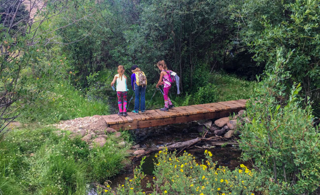
Photo by B4Studio - Shallow Creek Crossing
Ivy Creek Trail
#805 - Up & Back; gradual climb; Restroom at trailhead
The Ivy Creek trail follows Ivy Creek for the first several miles and then switchbacks take the hiker up and out of the Ivy Creek drainage. The trail crosses Ivy Creek several times and crossing in the early spring can be dangerous in the spring due to high water. The trail leaves the campground without any hard climbing. It will cross Ivy Creek within one mile of the trailhead and continue on a very gradual climb through open parks adjacent to Ivy Creek for another 1½ to 2 miles. This is a good place to turn around, as the trail then leaves the immediate creek bottom and climbs through spruce-fir stands before coming back to Ivy Creek.
Directions from Creede (16 miles): Travel towards Lake City from Creede on Hwy 149 for 6 miles to the turnoff for FDR #523 (Middle Creek Rd). From here, travel 4 miles to Lime Creek Rd. Stay to the left and follow FDR #528 for 3 miles to the intersection of Red Mountain Creek Rd (FDR#526). Continue on FDR # 526 for 3 miles to the campground for the trailhead.
Our Favorite Day Hikes
Fern Creek Trail to Little Ruby Lake
#815 - Up and Back (3.7 miles one-way)
The trail begins at Forest Road 522, and can also be traveled by smaller ATVs. The entire trail was burned over in 2013 by the Papoose Fire and offers a unique opportunity to witness forest regrowth. Use caution when going into this area. Watch for dead tree snags, flash flooding, debris flows. The trail begins by making a rather steady and strong 3.7 mile climb towards Little Ruby Lake. After reaching Little Ruby Lake, the trail grade flattens out, makes a short climb through a small patch of spruce to Big Ruby Lake.
Directions from Creede (17.5 miles): Travel towards Lake City from Creede on Hwy 149 for approx 16 miles. Turn left and travel to the southwest on Forest Road 522 (Fern Creek Road) for 1.5 miles to the trailhead.
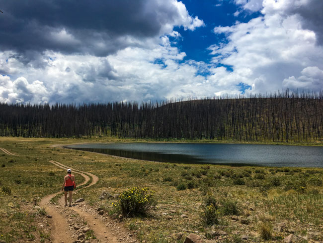
Photo by B4Studio - Ruby Lake
Inspiration Point
#789 (Wason Park) - Up and Back (3.5 miles one-way)
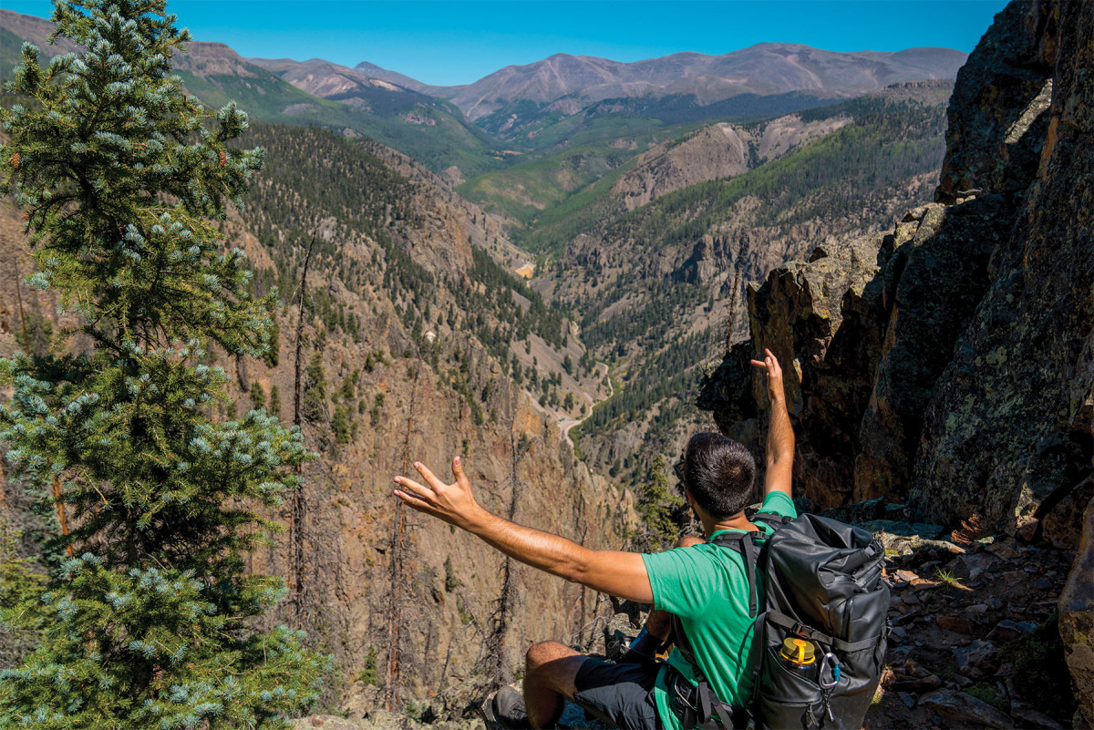
An early morning start is essential if you want to enjoy this hike. This trail offers beautiful views of town and amazing vistas of the Rio Grande valley. Make sure to acclimate to the altitude before setting off on this hike! Take plenty of snacks and water! This trail is also affectionately known to the locals as “Perspiration Point” because the tongue-dragging hike has no shade, is steep and contains a seemingly endless number of switchbacks (but spectacular views of town and the Rio Grande river valley). The trail often travels across jeep trails and at two points the trail overlaps the road. Watch for well placed markers and signs. From .9 miles to 1.1 miles, the trail is a bit dim. Trust the markers.At 1.1 miles, large groves of aspen and spruce provide welcome shade for the remainder of the hike. From 1.5 miles to the top, hikers will traverse several sections of rocky terrain. Even though the trail is well established in these areas, care should be taken. At 3.5 miles, travelers will arrive at Inspiration Point.So called, because the views from this rock promontory are truly inspirational. From this vantage point, visitors have unobstructed views of the Town of Creede, Mineral Count’s Historic Mining District, all the high mountains surrounding Creede and the legendary Rio Grande River. Bring your camera. You’ll want to capture these views.
Directions: Starts in Creede across La Garita Street from the gas station.
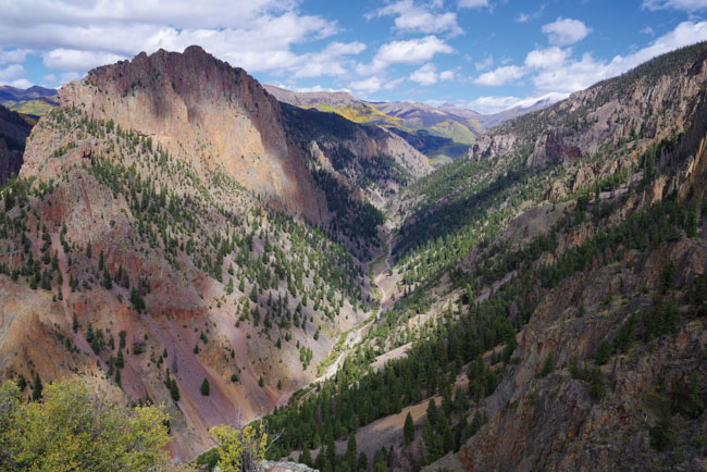
Photo by Bob Seago. East Willow Creek view from Inspiration Point Trail
Seepage Creek
FDS #509 - 2.5 miles one way
Begin your hike at the Forest Service gate. Hike up the road for 1 mile and cross the cattle guard until it opens to the meadow. Explore this pastoral setting that was home to Seepage Lake. The trail continues to cross the meadow and into the trees until you reach Ghost Lake.
Directions from Creede (about 11 miles): Travel towards Lake City from Creede on Hwy 149 for approx 10 miles and turn right onto Seepage Road/FDS 509. Follow the road and park to the right just before the Forest Service gate.
Bob Seago Seepage Creek
Phoenix Park
FDR #502.1A - Up and Back (2.5 miles one-way)
Start your hike at the Phoenix Park Trailhead. The first 2.2 miles of this hike is along a rough ATV/4x4 road, but makes for a lovely hike through aspen forests and open meadows along East Willow Creek. The road ends and hiking-only path begins at an old miners cabin. The 1/4 mile path leads you to another set of Creede’s famous waterfalls!Wildflowers will be bursting with color in the summer, and you may be lucky enough to spot a moose so don’t forget your camera!
Directions from Creede (about 3 miles): Drive north through town and up the Bachelor Loop Road (FDR #503) about 1/2 mile. Go right at the "Y" onto FDR#502 (East Willow Creek Road). Follow FDR#502 about 3 miles to the switchback and trail head.
Photo by B4Studio - Phoenix Park Hike
Spring Creek Pass to Snow Mesa
#787/813 - Up and Back (2.5 miles one-way)
Walk west crossing HWY 149 and scurry up the trail into the timber. This 2.5 mile trail is a fun and gradual climb. Well defined and great views of the Rio Grande Pyramid to the west. Once at tree line, the trail enters a gully that lies just below the Snow Mesa. Make the climb to the top and enjoy the 360-degree expansive views.
Directions from Creede (about 33 miles): Travel towards Lake City from Creede on Hwy 149 for approx 33 miles to Spring Creek Pass Summit. Park at the Spring Creek Pass parking lot on the west side of the highway.
Deep Creek Trail
#806 - Up & Back or Loop onto Lime Creek Road (arrange drop-off or pickup)
This is a great trail just outside of town.The trail follows Deep Creek up its canyon and alongside beaver ponds with beautiful mountain views and wildflowers! At the trailhead, first note the grave of a young pioneer; the trail switchbacks for first 1/8 mile through trees, then becomes a slight incline through the meadow. The meadow then gives way to in-and-out shade as you hike up and along the creek. You will come to a foot bridge about an hour in to the hike. Continue on up the drainage for a total of 9 miles until you reach FDR#528 (Lime Creek Rd). Have a friend shuttle a car or pick you up at this point (or drop you off for a down-hill hike!)
Directions from Creede (about 3 miles): Travel towards Lake City from Creede on Hwy 149 for approx 1/2 mile. Turn left off the highway onto Airport Road. Continue across the river. You will intersect FDR #550 (Deep Creek Road). Turn right and go up and around the corner; turn left onto the road and follow it up to the tree line.
Our Favorite All Day & Overnight Hikes
Wheeler Geologic Site via East Bellows Trail
#790 - Full Day or Multi Day - Up and Back (about 7 miles one-way)
This trail provides good hiking and horseback access to Wheeler Geologic Area, Half-moon Pass, and the La Garita Wilderness. Beautiful views and unique geologic features are the main attractions of this trail. Decent camping areas are not hard to find. Opportunities for fishing exist in East Bellows Creek. This trail allows for a good overnight backpack visit to Wheeler Geologic Area. After arriving at Hanson’s Mill. Those planning to hike to Wheeler Geologic Area should follow the trail delineated with the trailhead sign and registration box. This trail is closed to all motorized use. Within about three miles from Hansons Mill the trail will cross East Bellows Creek. The old sheep bridge is no longer usable, so hikers may get their feet wet. Crossing in the early summer can be dangerous. After the creek crossing, the trail will head up the west fork of East Bellows Creek, Canon Nieve. The trail joins the 4WD road about 1.5 miles before the geologic formations. At this junction go west (left) and follow the road to its end at a pole fence in a small meadow below Wheeler Geologic Area. The unique, picturesque features of the geologic area are about 0.25 to 0.5 miles north from the end of the road. The trail into Wheeler from the end of the 4WD road is well marked. It is an easy to follow trail but difficult in elevation gain that will take you on a loop trail around the formations. Note camping and campfires are not allowed within the Geologic Area.
Directions from Creede (18 miles): Travel towards South Fork from Creede on Hwy 149 for approx 8 miles to Pool Table Road. Hanson’s Mill Trailhead is 9.5 miles northwest on Pool Table Road.
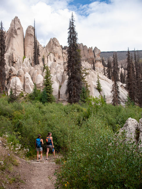
Photo by B4Studio - Hiking at Wheeler Geologic Monument
San Luis Peak - Hike a 14er
#882 to 465/813 to 465.5A - Full Day - Up and Back (11 miles round-trip to top of peak)
Drive to the trailhead by going up the Bachelor Loop (FSR 503) for 8 miles. Note, this is a dirt road and rough/rugged at norther end. From the unmarked parking area head northeast up the trail #882. This is a steep section. Finding the connection to the Colorado Trail (465/813) can be challenging as the connector trail is lightly used. The Colorado Trail is obvious though. Once you hit it, turn right (east). You should be able to see San Luis Peak in the distance across a wide open bowl. Follow the Colorado Trail down and around the big bowl until you reach a saddle at the base of the climb to the summit. Here you get off of the Colorado Trail and onto the Southern Ridge Trail (465.5A), which is rocky but very manageable and short. Reach the summit, snap a few photos, and take some time at the summit to admire the views that you earned! Once you've had your fill at the top, turn around and head back!
Directions from Creede (9 miles): Travel up FDR#504 (Bachelor Loop Road) towards Allan’s Crossing. Take FDR#503 towards the Equity Mine. From Equity Mine, continue another 1.5 miles to the trailhead of FDT#882. FDR#503 dead-ends and FDR#505 turns off to the left heading west up the hill. Park. The San Luis Pass Trail continues up West Willow Creek to the Divide.
Ivy Creek Trail
#805 - Multi-Day - Up & Back (9 miles to Goose Lake)
The Ivy Creek trail follows Ivy Creek for the first several miles and then switchbacks take the hiker up and out of the Ivy Creek drainage. The trail crosses Ivy Creek several times and crossing in the early spring can be dangerous in the spring due to high water. The first 2 1/2 miles are a gradual climb along the creek, in and out of spruce-fir stands. The trail then enters the timber and begins a steep mile long climb to the divide between Fisher and Ivy Creeks. Once at the open park on top, the trail flattens out considerably. Shortly, the trail enters the timber again, and passes through a series of parks and scattered timber for the distance to Goose Lake. The trail is well defined for its entire length. Good camping spots easy to find along most of the trail.
Directions from Creede (16 miles): Travel towards Lake City from Creede on Hwy 149 for 6 miles to the turnoff for FDR #523 (Middle Creek Road). From here, travel 4 miles to Lime Creek Road. Stay to the left at the “Y” and follow FDR #528 for 3 miles to the intersection of Red Mountain Creek Road (FDR#526). Continue on FDR # 526 for 3 miles to the campground for the trailhead.
Squaw Creek, Continental Divide and Weminuche Trail Loops
#818 - Multi-Day - Up and Back or Loop (20-30 miles)
Hiking deep within the vast expanse of Colorado’s Weminuche Wilderness brings you to the Rio Grande Pyramid (13,821ft), standing ancient, singular, and stoic. Most of Colorado’s Centennial 13ers have at least one nearby 14er, but not the Pyramid - it dominates its environs. The Window, a large notch in the volcanic dike running south from the mountain, adds even more character to the area. In somewhat interesting contrast to its rather dominating character, the area that surrounds Rio Grande Pyramid is different from that which surrounds most of Colorado’s high peaks. This area of the Weminuche Wilderness is fairly gentle, more pastoral than alpine. The Trails follow a gentle, broad valley, bordered by the treed slopes of rolling mountains, with the meandering Weminuche Creek running through the meadows of its floor. In this wilderness sanctuary large animals such as elk and moose make their home.
Directions from Creede (30-40 miles): Travel HWY 149 for approx 20 miles to FDR#520 (Rio Grande Reservoir Road). Travel ten miles to the Thirty Mile Campground. Or, continue along on FDR#520 for 10 more miles to Ute Creek Trailhead.
Photo by San Juan Sports - The Window
The Continental Divide Trail (CDT) and Colorado Trail
#813/465 - Full Day or Multi-Day
Near Creede, The CDT and Colorado Trail run together. From the deserts of New Mexico to the alpine peaks of the northern Rockies, the CDT winds its way through the stunning and diverse landscapes of the central United States, a ribbon that ties together many of the defining moments and movements in our nation’s history. The trail stretches across the United States some 3,100 miles between the borders of Mexico and Canada, twisting and turning to follow the spine of the continent. The Rio Grande National Forest features about 277 miles of the trail. Learn more at https://www.fs.usda.gov/
The Colorado Trail is Colorado’s premier long distance trail. Stretching almost 500 miles from Denver to Durango, it travels through the spectacular Colorado Rocky Mountains amongst peaks with lakes, creeks and diverse ecosystems.